
The suggested excursions on this map are suitable for both hikers and families with children but, for your safety, before heading off we recommend that you contact the Tourist Information Office (IAT) or the relevant associations to check that the tracks are accessible. The times indicated refer to the actual time spent walking and do not include rest stops. We also suggest that you check the weather forecast and wear suitable footwear and clothing.
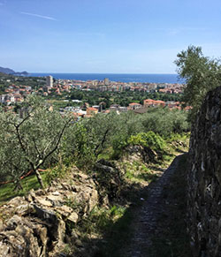
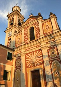
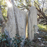
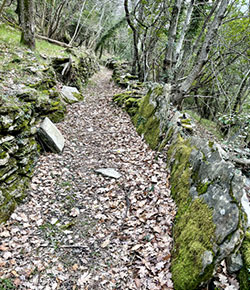
Chiavari is a lively tourist centre with a strong tradition of trade that still continues today. It has a distinctive old town featuring majestic palazzos and porticoes dating back to the Middle Ages when they opened onto the warehouses of the terraced merchant houses. Outside the town centre, Chiavari’s rural origins are evident in the landscape, which reflects the tenacity and industriousness of the Ligurians. The paths they created wind through terraced plots and woodland, revealing the secrets of the hills and rural life, formed of water management systems and earthworks, olive and grain mills and presses, as well as steep crêuze*. Hillside churches and chapels stand at the top of this network of ancient tracks, commanding unprecedented views and preserving some of the most impressive artworks in the area.
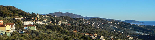
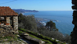
The green of the hills and the blue of the sea are the predominant colours of this land full of contrasts, which has inspired poets and been the breeding ground for great artists and craftsmen. From the first hill, the view sweeps from the highest peaks of the Ligurian Apennines in the east, dotted with villages on the hillsides, to the sea and beyond: the snow-capped Maritime Alps, the western coast of Liguria, the Tuscan islands and, on clear days, even Corsica with its jagged outline.
As far as nature is concerned, the current flora is the result of centuries of painstaking farm work on a harsh terrain that is difficult to tame. Oak and holm oak trees formed the original woodland cover, but in the Middle Ages the more productive chestnut groves spread, guaranteeing the survival of entire generations.
In the course of time, first the religious settlements, then the Republic of Genoa and the local feudal lordships contributed to the spread of substantial stonework to introduce the cultivation of olive trees, vines, cereals and vegetables. At the end of the 18th century and during the Napoleonic occupation, the countryside behind Chiavari resembled a large, well-kept and productive terraced ‘garden’.
Nature began to reassert itself following the gradual abandonment of the cultivated areas and is once again transforming the landscape: mixed woodland is replacing olive groves, the terraces are being colonised by Mediterranean scrub and wild animals are once again populating the countryside, brimming with biodiversity.
As the seasons change, the landscape varies, but the great thing about Liguria – and Chiavari is one of the best examples – is that you can enjoy it throughout the whole year.
Itineraries
Trail sign: a solid red square
Estimated time: 40 mins excluding breaks
Maximum length – Elevation gain: 2.5 km – 120 m
Level of difficulty: easy
 A number of crêuze climb up from the town centre, quickly taking you to the church of San Michele in Ri Alto, one of the oldest in the town.
Near the local cemetery of Ri, follow the solid red square trail sign along salita Ceive, which takes you to the crêuza of Ri, surrounded by a scattering of dwellings and terraces dominated by olive groves and the occasional bamboo plants along the edge of the ditches. The view from the small square below the church of San Michele in Ri Alto extends to the mouth of the river Entella and the eastern Tigullio area, as far as Sestri Levante.
There are two different routes leading upwards, either from piazza Del Buono, along the local Castagnola road, or from via Piacenza along the pedestrian path of salita San Michele near the ancient abbey of Saint Anthony of Padua.
They are both exposed to the sun in the morning and you can also start from the top and walk down them.
Trail sign: two horizontal red lines with slash
Estimated time: 3 h 30 mins excluding breaks
Maximum length – Elevation gain: 11 km – 400 m
Level of difficulty: easy/intermediate
The tour of the five towers is named after the four bell towers and the medieval tower encountered along the way. The route largely follows the ridge, crossing the adjoining territory of Leivi.
From the centre of Chiavari you reach salita al Castello, and the first tower – the castle of Chiavari – is located at the end of this climb. Continue uphill to Curlo and walk along alternating stretches of the historic crêuza and portions of the road, among olive groves and scenic views of the gulf and catch a glimpse of the first part of the Apennines. Continue to follow the two horizontal red lines with slash trail sign to the Bocco di Leivi, surrounded by the rural countryside and woodland areas. From Bocco di Leivi follow the road as far as the chapel of San Lorenzo, then turn left onto the nearby dirt road and proceed along the path that leads to a crossroads at Costa, on the ridge between the hamlets of Campodonico and Sanguineto. Continue on from here to the church of Maxena, where a steep crêuza takes you to San Pier di Canne.
Trail sign: two horizontal red lines
Estimated time: 1 h 10 mins
Maximum length – Elevation gain: 3.3 km – 250 m
Level of difficulty: easy/intermediate
This option is a great alternative to the first part of route 2 up to Curlo. It takes you off the road and up to the beautiful church of San Michele in Ri Alto along handy crêuze.
Take salita San Nicola, near the church of Rupinaro in the centre of Chiavari, signposted two horizontal red lines, then the local road of Carassona. When you reach the road to Leivi, turn right onto the footpath of San Michele and walk to the church of Ri Alto, which features a distinctive forecourt with rissêu (cobblestone mosaic). After passing under the archway of a pink house near the church, turn left onto the Paraxo footpath and continue through the olive groves, alternating between the crêuze and the back roads until you join route 2 at the Curlo cemetery, very close to the church of San Tommaso. From here you can descend to Rostio or continue along the Cinque Torri route.
Trail sign: a red cross
Estimated time: 1 h 40 mins
Maximum length – Elevation gain: 3.8 km – 250 m
Level of difficulty: easy/intermediate
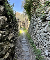
Take via G.B. Pianello, a side street off via Santa Chiara and follow the red cross trail sign along the footpath of Rissa, a narrow alleyway between dry stonewalls, which used to connect this zone and the church of San Tommaso in Curlo.
It takes you through olive groves, family vegetable patches and scattered houses in the typical Ligurian style of rural homes, offering views of the Gulf of Tigullio and the outskirts of the town. After a short stretch on asphalt, turn onto the Picettina footpath and join up with route 2 to Curlo. When you get to the church, continue on the sea side down towards the Costa del Pino, which leads to the provincial road for Leivi in Rostio. Then cross the San Pier di Canne district, which includes the ancient church of San Pietro to return to your starting point.
Alternatively, you can climb up from the Bona footpath, an old mule trail next to piazza Salvo d’Acquisto, which you can take from the side street, Traversa di via San Rufino.
Trail sign: horizontal white and red line
Estimated time: about 3 h 30 mins
Maximum length – Elevation gain: 9.2 km – 380 m
Level of difficulty: easy/intermediate
The route climbs up to the top of Monte Cucco, site of the Napoleonic telegraph, and continues up to the hamlets of Campodonico and Maxena, a combination of crêuze, woodlands and splendid views.
From via Fiume, signposted with horizontal white and red lines, take salita Descalzi up to the sanctuary of Nostra Signora dell’Ulivo in Bacezza. Mule trails and tracks lead up to what little remains of the telegraph. Continue along the ridge of Sant’Andrea di Rovereto, where you turn right and cross the valley of the Campodonico creek. Cross the stone bridge to the hamlet, then go back up through the houses and terraces, pass through the woods and keep going towards Costa on the Sanguineto ridge. Keep an eye out for the forks taking you to other local routes and head down towards the sea, following the trail signs, and enjoy the views along the coastline and the first part of the Appenines. When you get to the church of San Martino in Maxena, the steep crêuza behind it takes you to San Pier di Canne, then in no time to the centre of Chiavari.
Trail sign: two empty red squares
Estimated time: 2 hours to Mount Anchetta (4 hours to Montallegro)
Maximum length – Elevation gain: 4.5 km – 530 m
Level of difficulty: easy/intermediate

This is the path that leads from Chiavari to the Sanctuary of Montallegro, behind Rapallo, along steps, terraces, olive and chestnut groves. Part of it is also a section of the Sentiero Liguria trail (leg no. 8 – alternative). The numerous votive shrines testify to the historical significance of this holy trail.
From the San Pier di Canne zone in Chiavari, follow the two empty red squares trail sign. At the start, the track is the same as other routes so you need to watch out for the forks. When you get to Maxena, climb up a path near the ridge that takes you past the hamlets of Sanguineto and Campodonico, alternating stretches of mixed woodlands and Mediterranean scrub and offering views of the sea and the Appenines, until you get to mount Anchetta. When you get to the paved road near the Anchetta pass, you can keep going to Montallegro, following the <segnavia grafico>signs.
Trail sign: a solid red triangle
Estimated time: 2 hours to Mount Anchetta
Maximum length – Elevation gain: 4.7 km – 530 m
Level of difficulty: easy/intermediate
This alternative path takes you to the Anchetta pass along an old direct route. The first part crosses the valley of the watermills of the Campdonico creek, then it climbs up to the hamlet and from there to Mount Anchetta.
It starts at San Pier di Canne, alongside the sports centre (Palazzetto dello sport). Follow the trail along the valley bottom marked with a solid red triangle trail sign to get to the small chapel of San Bernardo. From here continue through the hamlet of Campodonico to the small saddle at the edge of the woods, where you need to watch out for the intersection with other routes. A steep climb takes you along the old mule track with dry stonewalls and differing surfaces, sometimes stepped and partly paved, in the middle of the woods. Near the ruins of some old rural farmhouses, not far from the crest, this path meets up with route no. 6 to Montallegro.
Trail sign: an empty red triangle
Estimated time: 3 h
Maximum length – Elevation gain: 6.7 km – 350 m
Level of difficulty: easy/intermediate

A dive into the hill’s rural history: the loop follows the old connecting roads used by the inhabitants of the hamlets of Maxena, Sanguineto and Campodonico.
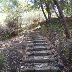
It starts at San Pier di Canne, alongside the sports centre (Palazzetto dello sport). Follow the trail along the valley bottom marked with an empty red triangle trail sign to get to the small chapel of San Bernardo. From the hamlet of Campodonico, climb to the small saddle at the edge of the woods and from there continue towards Costa until you get to a crossroads of routes. Follow the downhill track on the right, on the sea side. A lovely mule track crosses the terraced land and leads to the village of Sanguineto and its church, which is in a scenic position and has a beautiful forecourt made using the rissêu technique (cobblestone mosaic). Continue along the municipal footpath below as far as Maxena, surrounded by olive groves and here, once you are near the church of San Martino, take a flight of steps – la Montada – a little further down the valley. At first it runs alongside the road above and a few scattered houses, then it descends steeply as far as the Campodonico creek and takes you back to the starting point.
Trail sign: three solid balls positioned in a triangle
Estimated time: 2 h 30 mins
Maximum length – Elevation gain: 7.3 km – 350 m
Level of difficulty: easy/intermediate
In the dialect of Liguria, Maxea is the term used to describe dry stonewalls and stone constructions built without mortar to bind them together. On this route, you walk alongside extraordinary stone constructions: walls, terraces, old rural farmhouses and steps.
The path crosses the valley of Campdonico creek, like route 7 and 8. Along this stretch you can see the remains of old mills, some of which still have their wheels, and, near a votive shrine. Walk along the river as far as the footbridge over the Sanguineto brook, where the ancient footpath of the passaggi (passages) begins: a flight of over 900 steps lead to the small chapel of San Bernardo and to the foot of the hamlet of Campodonico. From here, a mule track descends to the old stone bridge and encounters some old rural farmhouses in the woods. When you get to the sea side above the hamlet of Sant’Andrea di Rovereto, keep walking to the hill of the Grazie along crêuze and tracks overlooking the coastline, surrounded by olive groves and old rural farmhouses. When you get to the sanctuary of Nostra Signora dell’Ulivo in Bacezza, head down along via Fiume close to the town centre.
Trail sign: solid red and white balls
Estimated time: 1 h 40 mins
Maximum length – Elevation gain: 4 km – 150 m
Level of difficulty: easy/intermediate
The hill of the Grazie offers impressive views of the Gulf of Tigullio, the sea and the rocky shores all year round.
Head along the seafront of Chiavari past the Torre Fara to Corso Buenos Aires. The starting point is located on the switchback above the railway tunnel. Part of it is also a section of the Sentiero Liguria trail (leg no. 8). The trail climbs in the shade of the holm oak woods following the solid red and white balls trail signs to the sanctuary of the Grazie. The view stretches from Sestri Levante to Portofino. Continue for a few hundred metres along the via Aurelia, then cross the road to pick up the track that climbs up through the woods to a splendid rural farmhouse in the middle of the olive grove: the view is exceptional. Keep following the trail signs along the local road of the Fonte to the sanctuary of Nostra Signora dell’Ulivo in Bacezza. At the switchback in front of the sanctuary you can head back along via Fiume or take via Prandina down to the town centre.
Trail sign: an inverted red T, occasionally on a white background
Estimated time: (not stated on the sign) 2 h
Maximum length – Elevation gain: 5.5 km – 490 m
Level of difficulty: easy/intermediate
This path is an interesting alternative route to the Anchetta pass, since it takes you to the small chapel of the Madonnetta behind the hamlet of Rovereto. The first part of the track is the same as route 10.
Follow the directions for route no. 10 and the invert red T trail signs until you get to a fork in the holm oak grove at the sanctuary of Nostra Signora delle Grazie. From here it climbs up to a settlement of rural farmhouses, then you turn left. Follow the woods of mount Cucco and continue along the ridge behind Sant’Andrea di Rovereto, in common with other routes where a paved road runs through dry stonewalls. After another small section of woods you arrive at the forecourt of the chapel, a true haven of peace. A charming cobbled mule track leads to the road for the Anchetta pass at a panoramic knoll between old rural farmhouses, with a splendid view of the Portofino promontory.
Trail sign: a solid red rhombus
Estimated time: 20 minutes
Maximum length – Elevation gain: 700 m – 160 m
Level of difficulty: easy/intermediate
Formerly used as a short cut linking the area of San Terenziano to the church of Maxena, and from there on to Montallegro, this route is well worth a visit.
Along the San Terenziano road you will find the solid red thombus trail sign on the sea side, at the beginning of a lane between cultivated fields and a smattering of houses. After crossing a footbridge over the stream, which here forms beautiful pools and cascades of water, climb up along the well-preserved crêuza. This crosses terraced terrain and mixed woodlands to a settlement and from there it’s a short walk to the church of San Martino in Maxena, offering scenic views over the town from its forecourt. From there you can continue along other signed routes.
